Home » Locations » Grey District »
Nature Wildlife
Easy Walk
Family Friendly
Some of the Grey District Walks for all to enjoy. From short loop walks to more adventurous day walks. Call into the isite for more information.

Time: 1- 2 Days
Distance: 18 km
The Croesus Track (part of the Great Walk) crosses the Paparoa Range between Blackball in the Grey Valley and Barrytown on the Tasman Sea Coast. It’s an ideal tramp for people new to tramping.
It’s is a beautiful walk into the landscape of the Paparoa Ranges. There is plenty of evidence of the local gold mining heritage, and a variety of vegetation and wildlife. Croesus Track is one of the few pack tracks on the West Coast that ascends over 1000 m above sea level, and its high points provide excellent views of the Southern Alps and the sea.
Time: 25 minutes loop
Distance: 1.5 km
Omotumotu Bush is the only substantial forest area remaining within the urban area of Greymouth. An easy walk with a short deviation to a lookout point with views of regenerating forest.

Time: 10 minutes loop
A loop walk of approximately 700 metres consisting of a narrow zone of Kowhai Forrest, half of which is bounded by the mudflats of Blaketown Lagoon. Some parts consists of boardwalks which follow through estuarine vegetation and unsuspecting wildlife.

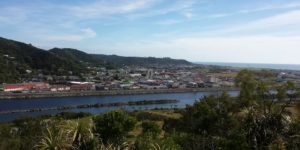
A zigzag uphill track to four lookouts. First lookout after a five minute walk provides a view of the town centre and the Grey River. Ten minutes from the first lookout is another rest area which provides a view of central Greymouth. From this point, the track is not as well formed but is easily negotiated by most walkers. After ten minutes from the previous lookout, a rock outcrop gives an excellent view of Cobden and a further five minutes reaches the last lookout, providing spectacular views of the lower Grey Valley areas.
Time: 10 minutes return
Distance: (560 m)
Leads to a concrete structure where a 5” U.S. Naval Gun was housed which provided a clear firing range of the Grey River mouth. Access: From Richmond Street in Cobden.
Time: 1 hour 45 minutes one way
Distance: 5.5 km one way
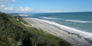
An interesting coastal/bush walk with good views and a few sites of historic interest along the way, ending at the carpark at the mouth of Seven Mile Creek Waimatuku. Unless you return via the same walk you will need to arrange transport back to your vehicle.

Time: 30-45 minutes
An easy walk within Greymouth itself, follow the top of the floodwall (on the riverside) towards the river mouth to see a monument to 300 men who died in West Coast mining disasters, watch people fishing, pass historic cranes and bird watching at the sandbar. You’ll get awesome views from the Blaketown Breakwaters all the way to Aoraki Mt Cook. Plus, this is a great place to watch the sunset.

Time: 45 minutes
Distance: 1.1 km loop
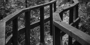
Be sure to take a torch on this walk to explore the fascinating tunnels once used by gold miners. In addition to the remnants of tunnels, races and walls of stacked stone you will pass through mature and regenerating forest. The walk can be covered in under 45 minutes but allow extra time for exploring. Sturdy walking footwear is recommended.
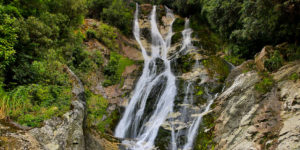
Time: 1 hour
Distance: 3.6 km
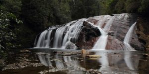
The path gently descends down to the Coal Creek valley though a mixed beech-podocarp forest. The pool below the falls is a nice place to cool off with a swim in the hot summer months. Take particular care to look out for underwater rocks and logs before jumping in.
Time: 2.5 hours
Distance: 7.2 km
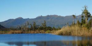
The track starts at the boat launching site opposite the Lake Brunner Lodge at Mitchells, on the southern end of the lake. It follows a boardwalk through wetlands and around the lake shore to a secluded camping and picnic area at Bain Bay. Parts of the track also pass through dense forest containing kahikatea, matai and rimu, and tall tree ferns. Both track and boardwalk can be immersed and impassable when the lake level is high. About halfway around, a double row of piles in the lake are the remains of an old L-shaped wharf. There are also remains of tramways and other equipment that delivered logs to be towed across the lake to a sawmill at Te Kinga.
Time: 30 min
Distance: 1.2 km return
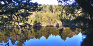
This easy walk starts from the lakeside carpark beyond the motor camp at the western end of Moana township. Cross the Arnold River Kotuku Awa footbridge at the lake outlet and follow the signs. It is within easy walking distance from town.
Time: 1 hr
Distance: 2 km return
This track is located on the Lake Brunner to Kumara Road at Mitchells. It starts approximately 300 m east of the Lake Brunner Lodge. A good track winds up through forest in the Lake Brunner Scenic Reserve to reach the tops of the Falls. You can sit on large granite boulders and enjoy the view out over the western end of Lake Brunner.

Time: 1 hr
Distance: 1.7 km loop
This track is signposted from the Arnold Valley Road 14 km north of Moana and 10 km south of Stillwater. Starting from the powerhouse, it first passes the hydro-electric power station and soon enters a stand of grand kahikatea-miro-rimu forest adjacent to the river within the Arnold River Scenic Reserve. It then climbs up to the top of a terrace and continues to wind around the terrace before descending to the river crossing point again.
Time: 8 hours
Distance: 7 km
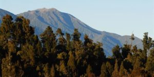
The track starts approximately 5 km west of Mitchells on the Inchbonnie-Kumara Road. The steady climb to the top of Mount French on the Hohonu Range is a full day tramp on an unformed route, but on a fine day the views down to Lake Brunner and inland to the Southern Alps reward the effort. The route is well marked, passing through mixed lowland rimu forest that also features some kaikawaka and silver pine.
Grey District Walks
![]()
West Coast Travel Centre
Mackay Street
PO Box 186
Greymouth
Phone: 03 768 7080
Fax: 03 768 7090
Email: info@westcoasttravel.co.nz